![](/images/other/stat-length.png)
![Randonnée V.T.T. Le Mesnil-Guillaume - Randonnée VTT du Mesnil Guillaume le 30/05/2010 23 km - Photo](https://media.geolcdn.com/t/1900/400/ext.pjpeg?maxdim=2&url=https%3A%2F%2Fstatic1.geolcdn.com%2Fsiteimages%2Fupload%2Ffiles%2F1524743154velo.jpg)
Randonnée VTT du Mesnil Guillaume le 30/05/2010 23 km
tracegps
Utilisateur
![Longueur](/images/other/stat-length.png)
![Altitude max](https://static1.geolcdn.com/siteimages/upload/files/1508320355ic_sort_altitude_max_24dp.png)
![Dénivelé positif](https://static1.geolcdn.com/siteimages/upload/files/1508320355ic_sort_den_pos_24dp.png)
![Km-Effort](/images/other/stat-length.png)
![Altitude min](https://static1.geolcdn.com/siteimages/upload/files/1508320355ic_sort_altitude_min_24dp.png)
![Dénivelé négatif](https://static1.geolcdn.com/siteimages/upload/files/1508320355ic_sort_den_neg_24dp.png)
![Boucle](https://static1.geolcdn.com/siteimages/upload/files/16400158638029165_repeat_loop_refresh_sync_direction_icon.png)
![V.T.T.](https://static1.geolcdn.com/sitytour/trail-icons/202.png)
2h00
Difficulté : Difficile
![Scannez ce code QR pour ouvrir la randonnée dans l'application SityTrail](https://capi.geolives.com/qq0zvz2zws4bq2lad0pu/sitytour/trails/105099/qr.png?size=200)
Application GPS de randonnée GRATUITE
À propos
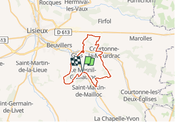
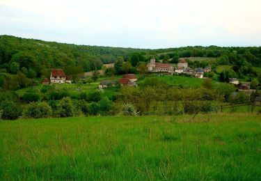
Randonnée V.T.T. de 22 km à découvrir à Normandie, Calvados, Le Mesnil-Guillaume. Cette randonnée est proposée par tracegps.
Description
Très belle randonnée, au départ petite cote en montée, suivie d'une partie roulante et rapide, un vrai plaisir. Puis passage dans une forêt très technique et roulante en même temps. Ensuite descente vers Courtonne la Meudrac, puis longue montée difficile mais faisable on Bike. Ensuite un peu de route et de chemin rapide pour enfin accéder à une descente d'enfer, longue, très rapide (55 km/h) avec des virages appuis, on a envie de la refaire plusieurs fois. Ensuite passage dans un petit tunnel sous la ligne de chemin de fer, puis traversée de Glos pour attaquer une longue montée pour enfin redescendre vers Le Mesnil Guillaume par des descentes tantôt rapides tantôt techniques. Bonne rando, au plaisir !
Localisation
Commentaires
Randonnées à proximité
![Randonnée Marche Beuvillers - BEUVILLERS LISIEUX - Photo](https://media.geolcdn.com/t/375/260/ae95811b-07e5-4015-95d9-7c2a55a31b21.jpg&format=jpg&maxdim=2)
![Marche Marche](https://static1.geolcdn.com/sitytour/trail-icons/101.png)
Marche
![](/images/other/stat-length.png)
![](https://static1.geolcdn.com/siteimages/upload/files/16400158638029165_repeat_loop_refresh_sync_direction_icon.png)
![Randonnée Marche Glos - Au tour. De GLOS - Photo](https://media.geolcdn.com/t/375/260/0b2ddb1a-d30a-40de-af60-29f1141fbaef.jpg&format=jpg&maxdim=2)
![Marche Marche](https://static1.geolcdn.com/sitytour/trail-icons/101.png)
![Randonnée Marche Prêtreville - Autour de Prêtreville - Photo](https://media.geolcdn.com/t/375/260/ext.jpg?maxdim=2&url=https%3A%2F%2Fservices.sitytrail.com%2FGeolivesWS%2FDownloadMedia.ashx%3FTrailID%3D317526%26Media%3D16768_4.jpg)
![Marche Marche](https://static1.geolcdn.com/sitytour/trail-icons/101.png)
Marche
![](/images/other/stat-length.png)
![](https://static1.geolcdn.com/siteimages/upload/files/16400158638029165_repeat_loop_refresh_sync_direction_icon.png)
![Randonnée V.T.T. Glos - Autour de Glos - Photo](https://media.geolcdn.com/t/375/260/ext.jpg?maxdim=2&url=https%3A%2F%2Fservices.sitytrail.com%2FGeolivesWS%2FDownloadMedia.ashx%3FTrailID%3D215108%26Media%3D15691_3.jpg)
![V.T.T. V.T.T.](https://static1.geolcdn.com/sitytour/trail-icons/202.png)
![Randonnée Marche Lisieux - Autour de la Basilique de Lisieux - Photo](https://media.geolcdn.com/t/375/260/ext.jpg?maxdim=2&url=https%3A%2F%2Fservices.sitytrail.com%2FGeolivesWS%2FDownloadMedia.ashx%3FTrailID%3D214887%26Media%3D15436_3.jpg)
![Marche Marche](https://static1.geolcdn.com/sitytour/trail-icons/101.png)
Marche
![](/images/other/stat-length.png)
![](https://static1.geolcdn.com/siteimages/upload/files/16400158638029165_repeat_loop_refresh_sync_direction_icon.png)
![Randonnée Marche Valorbiquet - Autour de l'Orbiquet - La Chapelle Yvon - Photo](https://media.geolcdn.com/t/375/260/ext.jpg?maxdim=2&url=https%3A%2F%2Fservices.sitytrail.com%2FGeolivesWS%2FDownloadMedia.ashx%3FTrailID%3D129765%26Media%3D13305_4.jpg)
![Marche Marche](https://static1.geolcdn.com/sitytour/trail-icons/101.png)
Marche
![](/images/other/stat-length.png)
![](https://static1.geolcdn.com/siteimages/upload/files/16400158638029165_repeat_loop_refresh_sync_direction_icon.png)
![Randonnée Marche Valorbiquet - La Chapelle Yvon - Photo](https://media.geolcdn.com/t/375/260/e430d8c7-de01-4000-aae1-ee161d0bbeaf.jpg&format=jpg&maxdim=2)
![Marche Marche](https://static1.geolcdn.com/sitytour/trail-icons/101.png)
Marche
![](/images/other/stat-length.png)
![](https://static1.geolcdn.com/siteimages/upload/files/16400158638029165_repeat_loop_refresh_sync_direction_icon.png)
![Randonnée Marche Valorbiquet - Autour de Hameau Bourdon - Photo](https://media.geolcdn.com/t/375/260/354e6b0d-39c6-48d3-817d-188556b774e7.jpg&format=jpg&maxdim=2)
![Marche Marche](https://static1.geolcdn.com/sitytour/trail-icons/101.png)
Marche
![](/images/other/stat-length.png)
![](https://static1.geolcdn.com/siteimages/upload/files/16400158638029165_repeat_loop_refresh_sync_direction_icon.png)
![Randonnée Marche Valorbiquet - 2023 03 19 St Cyr par chemin du Val - Photo](https://media.geolcdn.com/t/375/260/3d2638f6-9710-4546-b91c-73376df6ac8a.jpg&format=jpg&maxdim=2)
![Marche Marche](https://static1.geolcdn.com/sitytour/trail-icons/101.png)
Marche
![](/images/other/stat-length.png)
![](https://static1.geolcdn.com/siteimages/upload/files/16400158638029165_repeat_loop_refresh_sync_direction_icon.png)